


"The mournful whistle of a distant locomotive recalls to my ear the murmuring of countless springs, the sighing of pines, and all those indescribable sounds of nature which awaken the soul and transport it to distant scenes of youth and hope." Mark Twain

It’s considered one of the most remote places in the continental U.S. for those daring enough to take Hwy 50-dubbed the Loneliest Highway in America-to get here. This part of the country is not only known for its extreme darkness and unmatched stargazing, but also for its silence. Perched on the edge of eastern Nevada, Ely, a boom to bust mining town, is sandwiched between mountain ranges, some over 12 k, making it the perfect launch pad for outdoor adventures. According to White Pine County Tourism, and even considering its boom to bust history, Ely has always been a “gathering place for tribes, travelers, and treasure hunters.”
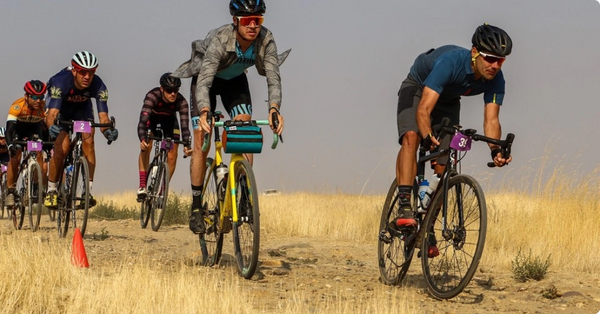
While the mineral treasures have all but dried up, the new ore rush for Ely is endless miles of gravel roads that spool out into the Great Basin, making it the perfect place to explore on two wheels to get a deeper sense of its expansive geography, unique flora and fauna, and colorful history.
The pinyon pine, which dot the mountainous Great Basin landscape, is a sacred tree to the Shoshone, a hunting and gathering peoples who have inhabited Eastern Nevada since prehistoric times. Many Southwest tribes trace their origins to the pinyon pine, especially in harsher climates like Ely and the larger Great Basin area, as its nuts represented a life-or-death winter food source.The Western Shoshone has inhabited Eastern Nevada since prehistoric times and evidence suggests that tribes have been gathering in Hercules Gap, and other parts of this valley, and holding Sun Dance ceremonies for centuries. Speaking of the Shoshone, they still have a presence here in Ely, in fact, they’re a sovereign nation that resides on a reservation just south of town.
Founded as a stagecoach station along the Pony Express and Central Overland Route, it was the discovery of copper in 1906 that really put Ely on the map. This sparked massive railroad development and town growth, but when those veins evaporated, so too did the mining boom. Today, there are fewer than 5k people that live in this once bustling railroad and mining town.

So what brings folks to this remote region these days? Well, it’s a combination of factors, but to begin it’s the home of the Nevada Northern Railway Museum, which features the Ghost Train of Old Ely, a working steam-engine passenger train that travels the historic tracks from Ely to the Robinson mining district. It also has the East Ely Railroad depot museum, one of the most complete historic railroad yards in the nation. And White Pine County has the most 11,000+ ft peaks in Nevada, Wheeler Peak being the tallest at over 13,000 ft above sea level, which make it the perfect destination for outdoor enthusiasts. Speaking of the outdoors, few folks know that Ely is home to a hidden gem, Great Basin National Park, which sits south of town on the border of Utah. But what’s really going to start getting folks to explore this region are the hundreds of miles of gravel roads that spider out into the Great Basin, many of them leading to ghost towns or hot springs or high mountain passes or National Parks or all of the above.
I have traversed this lonely desert corridor for 30 years, so this isn’t my first time in Central Nevada. In fact, the first adventure I had in this region was 12 years ago, two hundred miles to the west of here in the Humboldt-Toiyabe National Forest when a two wheeled exploration of the long forgotten (at that time) Toiyabe Crest Trail nearly turned fatal. What we thought would be an eight to ten hour day on the mountain bike, exploring a high alpine trail, became the proverbial Gilligan’s Island “three hour tour” and lead to me spending the night at 10,000 ft in a sage bush and nearly having the National Guard called to come and extract us. That experience did little to dampen my fascination with this landscape, which is filled with ghost towns, petroglyphs, hot springs, ancient and abandoned mines, endless miles of dirt roads, and only lit my fire to continue exploring this vast region of land so that I could dig a little bit deeper to help expose the extensive riding options that exists here.

Of all the scenic gravel cycling routes in Nevada, this one is a hidden gem. Situated at 7,300 feet and ascending to 9,363, the Success Loop can be ridden either direction but I prefer counter clockwise because you get into the most scenic aspects of this route quicker. After leaving the downtown historic train depot, a zig and a zag through the neighborhoods gets you onto gravel and heading south towards Cave Lake State Park, the southern entrance to this stunning ride. With the Ward Mountain Range to the west and the Scheel Creek Range to the east, it’s easy to feel small in this high desert landscape. Few people outside of this region know about this loop, which makes it the ideal place to explore on two wheels. After a bit of pavement through the park, the road turns to gravel and you begin to ascend through stunning groves of shimmering aspens with the craggy granite cliffs of the Schell Range looking over your shoulder. The descent off Success Summit is stunning, with aspens lining the gravel for much of it, flanked by running water at times, and road conditions nearly perfect, it’s no wonder this is considered one of Nevada’s best kept ride secrets.

Speaking of forgotten times, there are folks still using this expansive landscape to run sheep on, much like the ancient Basque people who immigrated to the western United States from their homeland in the Pyrenees Mountains, first arriving in California around 1850, drawn by the discovery of gold. It was here in the American west that many of these young men, with instruction from a seasoned sheepherder, learned how to care for sheep.It’s a lesson in real time and a reminder that there’s so much history in this rugged landscape. While I didn’t see any, there may’ve been arborglyphs-tree carvings made in the bark of aspen trees by Basque sheepherders throughout North Eastern Nevada- in the dense canopy while I rocketed down from Success Summit. Unfortunately, like the sheepherders who carved them, the arborglyphs are vanishing from Northern Nevada, as the trees succumb to the ravages of time, fires, development, vandals, disease, insects, and old age.
It’s fitting that the Success Loop ride ends where it began, the East Ely Railroad depot. As one of the most complete historic railroad yards in the nation, there’s no better place to step back in time to get a glimpse of Ely’s copper mining roots and the West’s fascinating locomotive history than here. And that lonesome whistle of the trains that roll through here, as Twain stated, are a great reminder that this region is full of countless springs, ancient pines, and indescribable sounds and scenes of nature that allow us to escape daily life. For those explorers looking to seek out wild and expansive gravel road adventures, Ely, NV, is just the place for you.